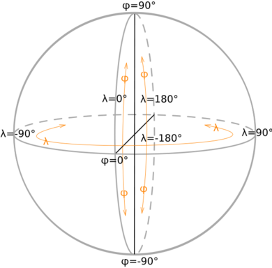
Geographic coordinate system

A geographic coordinate system expresses every location on Earth by two of the three coordinates of a spherical coordinate system which is aligned with the spin axis of Earth.
First and Second Dimensions: Latitude and Longitude
Borrowing from theories of ancient Babylonians, later expanded by the famous Greek thinker and geographer Ptolemy, a full circle is assigned 360 degrees (360°).
- latitude (Lat.) is the angle between any point and the equator. Lines of constant latitude are called parallels. They trace circles on the surface of Earth, with each pole being 90 degrees (north pole 90° N; south pole 90° S). The equator, an imaginary line that divides the globe into the Northern and Southern Hemispheres, is located at 0° latitude.
- longitude (Long.) is the angle east or west of an arbitrary point on Earth: The Royal Observatory, Greenwich (UK) is the international zero-longitude point (longitude=0 degrees). The antipodal meridian of Greenwich is both 180°W and 180°E. Lines of constant longitude are called meridians. The meridian passing through Greenwich is the Prime Meridian. Unlike parallels, all meridians are halves of great circles, and meridians are not parallel: they intersect at the north and south poles.
By combining these two angles, the horizontal position of any location on Earth can be specified.
For example, Baltimore, Maryland (in the USA) has a latitude of 39.3° North, and a longitude of 76.6° West (Template:Coor d). So, a vector drawn from the center of Earth to a point 39.3° north of the equator and 76.6° west of Greenwich will pass through Baltimore.
This latitude/longitude "webbing" is known as the common graticule. There is also a complementary transverse graticule (meaning the graticule is shifted 90°, so that the poles are on the horizontal equator), upon which all spherical trigonometry is ultimately based.
Traditionally, degrees have been divided into minutes ( ′ ) and seconds ( ″ ). There are several formats for degrees, all of them appearing in a Lat.-Long. order:
- DM Degree:Minute (49:30.0-123:30.0)
- DMS Degree:Minute:Second (49:30:00-123:30:00)
- DD Decimal Degree (49.5000-123.5000), generally with 4 decimal numbers.
To change from DM or DMS to DD, Decimal degrees = whole number of degrees, plus minutes divided by 60, plus seconds divided by 3600. Decimal division is now the most common and standard.
The equator is obviously an important part of this coordinate system, it represents the zeropoint of the latitude angle, and the halfway point between the poles. The equator is the fundamental plane of the geographic coordinate system. All spherical coordinate systems define such a fundamental plane.
Latitude and Longitude values are established based on an associated Geodetic system or datum such as WGS 84. In other words, the same exact point on the earth’s surface will be expressed by different latitude and longitude values, depending on the reference datum.
In popular GIS software, data projected in latitude/longitude is often specified via a 'Geographic Coordinate System'. For example, data in latitude/longitude with the datum as the North American Datum of 1983 is denoted by 'GCS_North_American_1983'.
Third dimension: altitude, height, depth
To completely specify a location on, in, or above Earth, one has to also specify the elevation. The elevation specifies the vertical position of the location relative to some measure of Earth's surface. This could be expressed in terms of the vertical distance to Earth below, but, because of the ambiguity of "surface" and "vertical", is more commonly expressed relative to a more precisely defined datum such as mean sea level (as height above mean sea level) or the geoid. The distance to Earth's center is a practical coordinate both for very deep positions and for positions in space.
Various elevation / height coordinates either with respect to the surface or some other datum are altitude, height, and depth.
Geostationary coordinates
Geostationary satellites (e.g., television satellites ) are over the equator. So, their position related to Earth is expressed in longitude degrees. Their latitude does not change, and is always zero over the equator.
See also
- Geographic information system (GIS)
- Global Positioning System (GPS)
- Geographic coordinate conversion
- geocodes
- Tropic of Cancer
- Tropic of Capricorn
- Great-circle distance explains how to find that quantity if one knows the two latitudes and longitudes.
- Map projection
- Universal Transverse Mercator coordinate system
